Cascade Environmental
  • Home
  • About
    • The Company
    • Team Profile
    • Corporate Responsibility
    • Careers
  • News & Events
  • Services
    • Environmental Planning
    • Recreation Management
    • GIS/Mapping
  • Portfolio
  • Testimonials
  • Contact Us
  • Search
  • Menu Menu
  • LinkedIn
  • Twitter
  • GIS/MAPPING

PreviousNext
1234567

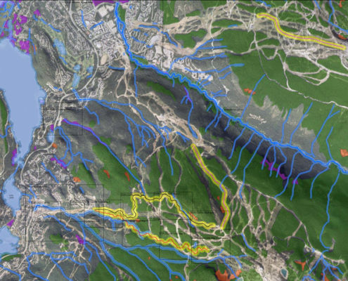
GIS is a spatial approach to combining, analyzing, and displaying information and data. By integrating hardware, software, and data, GIS allows us to view, understand, analyze, interpret, and visualize data in many ways. The relationships between data layers and geographic proximities reveal patterns and trends that can be displayed on maps that would otherwise be difficult to comprehend.

As a fully licensed operator of ESRI ArcInfo 10, PCI Geomatica, Trimble Pathfinder Office, and Garmin Mapsource software, Cascade can perform technically advanced spatial analysis, provide high accuracy GPS surveying, and produce top quality cartographic mapping output. Cascade is proud to own and operate leading edge GPS equipment including a GLONASS enabled Trimble ProXRT receiver equipped with a Zephyr antenna and Nomad data logger.

Cascade produces colourful and informative professional quality cartographic products. Mapping products generated by Cascade are used in reports and legal documents, informative kiosks, bike race maps and marketing materials. Additionally Cascade owns an HP Designjet 4500ps plotter which provides the ability to print large format poster sized maps on both regular and glossy photo paper. Our mapping services include the following:

  • Terrestrial Ecosystem Mapping (TEM)
  • Opportunities & Constraints Mapping
  • View-shed Analysis
  • Habitat Modelling
  • LiDAR Mapping
  • Land Use Assessments
  • Watershed Delineation
  • Cartographic Mapping
ENVIRONMENTAL PLANNING
RECREATION MANAGEMENT

RELATED CASE STUDIES

Trans Canada Trail

2010 Winter Olympic & Paralympic Games

Regional District of Okanagan Similkameen Trails Master Plan

  • Environmental Planning
  • Recreation Management
  • GIS/Mapping

What People Say About Us

"We owe much of our success at Canadian to Dave Williamson and his crew at Cascade. For well over a decade they have been a great sounding board and help in translating our ideas into language that the government understands and accepts. This team has a real wealth of practical intelligence. If they wrote this testimonial it would have been way better."

- Allen Crawford, CEO Canadian Wilderness Adventures
Read more

Quick Links

  • Recreation Management
  • Environmental Planning
  • GIS/Mapping
  • The Company
  • Testimonials
  • Portfolio
  • Contact Us

Latest Posts

  • SeaSketch – Stakeholder EngagementNovember 8, 2020 - 11:49 am
  • Wildlife Survey for IMAX Movie Superpower Dogs on Guideon CirqueApril 23, 2018 - 3:51 pm
  • Chamber Après at FORLiSEJanuary 17, 2017 - 10:33 am
  • Happy Holidays!December 1, 2016 - 1:46 pm

Categories

  • Environmental Assessment
  • Environmental Monitoring
  • Fish Survey
  • GIS
  • News
  • Recreation Management
  • Uncategorized
  • Wildlife Survey
© 2020 Cascade Environmental. | Website by Whistler Web & Print
  • LinkedIn
  • Twitter
Scroll to top